
Replumbing the Klamath for People, Fish, and Wildlife: A Nature-Based Solution for Drought and Desertification in Lower Klamath Lake
The Klamath Drainage District (KDD) has engaged with several stakeholders and federal agencies on a project to create more resilient wetlands in the Lower Klamath Lake National Wildlife Refuge while creating protections for landowners in KDD to ensure agriculture is sustainable in the district.
The project, titled “Replumbing the Klamath for People, Fish, and Wildlife: A Nature-Based Solution for Drought and Desertification in Lower Klamath Lake“, reworks KDD canals to reconnect Lower Klamath Lake with the Klamath river, provide passage for fish to the wetlands in the Lower Klamath refuge, provide water for the wetlands of Lower Klamath Refuge, and work with landowners to provide incentives for creating rotating wetlands on their land while offering coverage to landowners for incidental take of endangered or threatened species.
The various collaborators working on Replumbing the Klamath include:
- Klamath Drainage District
- Modoc Nation
- California Waterfowl
- Ducks Unlimited
- Klamath Tribes
- Yurok Tribes
- Klamath Watershed Partnership
- Willamette Partnership
- USFWS
- NMFS
- USDA
- NRCS
- State of Oregon
Participating jurisdictions include:
- US Bureau of Reclamation
- US Fish and Wildlife Service
- USDA, Natural Resource Conservation Service
- NOAA, National Marine Fisheries Service
- Oregon Water Resources Department
- Oregon Department of Environmental Quality
- Oregon Department of Fish and Wildlife
- California Department of Transportation
- California Department of Fish and Wildlife
The following is from letters sent to the federal agencies and services that will be a part of overseeing the project. It outlines the scope of the project as well as the goals for Replumbing the Klamath.

Resilience Vision
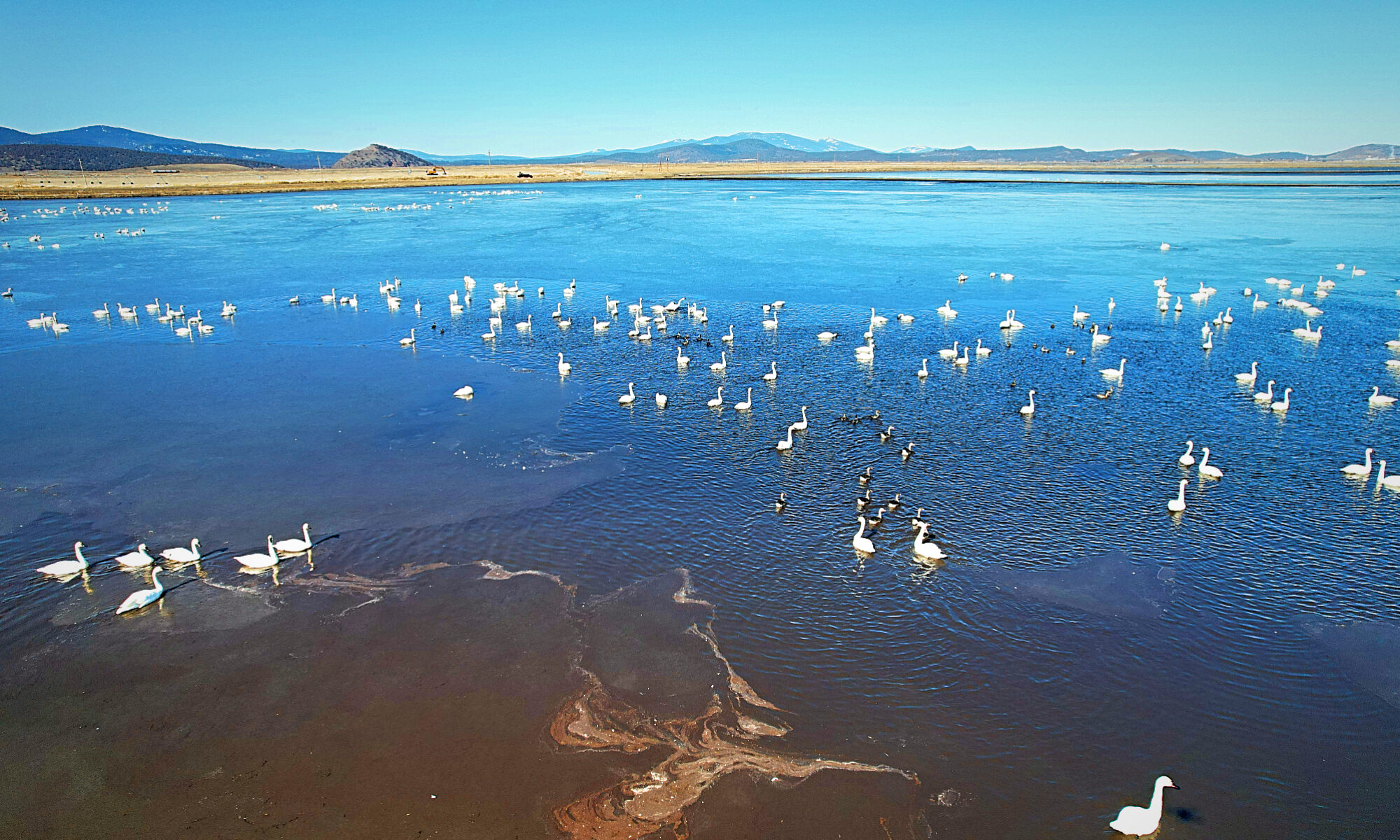
The Lower Klamath National Wildlife Refuge (LKNWR) was the first refuge in the nation established specifically for the long-term protection of migratory waterfowl. But this cornerstone of the US refuge system, critical to both Pacific Flyway waterfowl and threatened and endangered fish like the Lost River and shortnose suckers, went completely dry in 2021 due to persistent drought and competing needs for a limited supply of water. Species that once thrived in the LKNWR are now in decline across the entire Klamath Basin. The Klamath Reclamation Project, a 100+ year-old irrigation project in the Basin, wants to be part of the solution for the benefit of residents and species facing climate impacts, like persistent drought, in the region. With the recent drying of LKNWR, the Klamath Drainage District (KDD) is providing critical migration habitat for waterbirds, but there is not enough to go around – agricultural lands can’t fully meet species’ needs, and farmers haven’t been getting the water they need to make their operations financially sustainable.
Today, removal of four dams on the Klamath River raises the stakes and will drastically alter the area’s hydrology yet again. The impending return of salmon to the Basin is also invigorating tribal, state, and federal stakeholders to find innovative solutions to meeting salmon habitat and life cycle needs. Partners will need to work together to find a better way to balance human and wildlife needs in a place where historical practices and changes to the landscape have undermined the land’s ability to catch, store, and transmit water. Restoring and reconnecting the Basin wetlands is a simple solution that will help improve water availability for both environmental and agricultural uses, reestablish continentally important wetland habitat for birds and fish, increase resilience to climate change, and promote a sustainable approach to agricultural production that supports the local economy.
The Lower Klamath Lake Working Group has formed with more than a dozen stakeholders and a goal preparing for salmon reintroduction after four dams on the Klamath River are removed by returning water to the refuge and improving the natural capacity for water storage in the region to create a more resilient Klamath Basin in the face of escalating climate change. The first project proposed in this effort will be re-establishing hydrologic connectivity between the Klamath River and LKLNWR through the Ady and North Canals. A feasibility analysis is needed to determine the physical barriers and earth-moving needs; highlight potential biological/ecological impacts; and guide a plan for administrative compliance and feasibility.
Upon completion of the feasibility analysis, implementation work can begin. The existing Ady and North Canals may need improvement of the ditch banks to ensure KDD private lands are safe from flooding as more water is sent down the canal. Outside of exploring possible modifications to the canal ditch banks, possible diking or earthwork may be needed at the refuge to ensure 4,000 acres at the Unit 2/Sheepy Lake connection point are hydrologically reconnected, with potential for an additional 6,000 acres to be flooded further. Establishing a live connection (fish passage options) for fish that lost connection to Lower Klamath Lake with the construction of a railroad embankment would also be needed.
Regional Context
A conceptual restoration plan is being developed through the Lower Klamath Lake Working Group collaborative that engages partners from across the public and private sectors: state, federal, and tribal governments, drainage and irrigation districts, landowners, and non-profit partners. Note that this collaborative and the associated plan is funded by the NRCS. The plan is building upon the KDD’s modernization planning (NRCS Planning) in partnership with the Farmers Conservation Alliance that is largely designed for fishery protections and water use efficiency including fish screening, delivery efficiencies and increased water measurement. Building upon this existing irrigation modernization planning effort KDD is already a part of a feasibility analysis would move us another step toward implementation.
Other planning and reports for the region include nature-based solutions for climate resilience. The Upper Klamath Basin Watershed Action Plan (2021) names channel reconstruction, wetland restoration, and irrigation modernization/efficiency models as methods of creating climate resilience.
A report entitled “Preparing for Climate Change in the Klamath Basin” released by the National Center for Conservation Science & Policy and The Climate Leadership Initiative in 2010 recommends the reconnection of streams, rivers, side channels, wetlands, and floodplains to provide more resiliency via hydrologic connectivity as well. The basis of the Ady and North Canals’ hydrologic connectivity project stems from the Reoperation of the Klamath Project white paper created in February 2023 by Moss Driscoll of the Klamath Water Users Association. This paper calls out specific actions and locations of these actions, to begin the restoration of hydrologic connectivity in the region, starting with the Ady and North Canals. The implementation of the restoration plan will prioritize awards to local tribal interests for the survey, design and constructions of the work, as consistent with Oregon procurement law, due to their involvement in the Working Group.
Our project would revive a long-suffering agricultural community and their ecosystem, including creating more potential habitat for endangered species, protecting migrating birds that rely on the Pacific Flyway, and supporting the nearly 70,000 people in the Klamath Basin comprised of displaced tribespeople, legacy agriculture families, migrant farmworkers, and other community members vital to a thriving rural community.
Proposed Activities and Outcomes of Track One
Track One is requesting funding for the feasibility analysis of the conceptual restoration plan implementation. The scope of feasibility analysis will include:
Physical Feasibility
- Surveying – to determine specific geographic scope of the project.
- Inundation study – determining what would cause flooding and how. Will this project flood property owners south of the Refuge? Can this be mitigated by interior levees? Exploration of incentive programs or easements in lieu of levees as a possibility
- Is the elevation of Stateline Highway high enough to accommodate the new water levels with adequate freeboard?
- Elevation baseline of Unit 2 to inform flooding extent and need or no need for infrastructure improvement (levee height, width, water control structures, fish screens, etc.).
Biological/Ecological Feasibility
- Evaluation of wetland management scenarios considering water availability, timing, fish needs, Project operations, etc.
- Ingress and egress needs of resident and anadromous fish.
- Potential fish screening types/costs/placement scenarios.
- Potential for sucker recovery efforts (redundant population, functional population via connection to historical spawning areas, grow out). If interior levees were used for flood management, would that sacrifice the live-flow connection to Sheepy Creek (which is important as that provides spawning habitat)
Administrative Feasibility
- Permitting compliance.
- Cultural compliance.
- NEPA/ACOE/EPA requirements.
- Water sharing agreements.
- Water rights – are these limiting or is there opportunity in existing or future water rights?
- Landowner outreach to those south of LKNWR that could be impacted by flooding.
- Liability coverage availability and options.
- Projected costs and financing options.
The activity to be funded is the feasibility analysis; the outcome is a guide for implementation of hydrologic connectivity between the Klamath River and LKLNWR using the Ady and North Canals. This relates to our vision by creating greater climate resiliency in the Klamath Basin through restoration of natural hydrologic patterns. This project aligns with NOAA’s program priorities of promoting regional coordination and collaboration (the feasibility analysis will assist our Working Group’s work together), equity and inclusion (the feasibility analysis considers cultural and economic impacts), enduring capacity (by funding the feasibility analysis this frees up NRCS funds to continue funding the Working Group activities over the next several years), and creates risk reduction from climate impacts via ecological function restoration (increased flow, storage, etc.).
Proposed Activities and Outcomes of Track Two
Track Two will request funding for the implementation of the restoration plan pending, and somewhat reactive to the feasibility study. Generally, the scope of implementation for restoration would include:
- Modify the existing North & Ady Canals to reconnect the Klamath River and Lower Klamath Lake at LKNWR’s Unit 2, allowing fish access to perennial wetlands for the first time since railroad construction.
- Extend the North Canal across the Stateline Highway into LKNWR, connecting to the refuge’s P Canal system and delivering water to the refuge’s wetlands and cooperative grain lots.
- Create a Habitat Conservation Plan or Biological Opinion to provide KDD landowners coverage for incidental take of endangered or threatened species that could result from canal improvements.
- Establish a voluntary incentive program for KDD landowners to establish rotational perennial wetlands for water bird habitat and soil health. Landowners in this program would also have priority access to refuge co-op lands.
- Increase water delivery to LKNWR, starting with establishing guaranteed delivery amounts and quantitative thresholds for water delivery to the refuge in dry, normal, and wet years and prioritizing water delivery during the fall/winter period to flood grain for waterfowl and pre-irrigate co-op lands in the LKNWR. (Success of this program and rehabilitation of LKNWR habitat values would also require restoration of other water sources available to the refuge.)
The activity to be funded via track two is the implementation of the restoration plan; the outcome is hydrologic connectivity between the Klamath River and LKLNWR using the Ady and North Canals. This relates to our vision by creating greater climate resiliency in the Klamath Basin through restoration of natural hydrologic patterns. This project aligns with NOAA’s program priorities of promoting regional coordination and collaboration (assisting our Working Group’s work together), equity and inclusion (helps secure habitat for culturally significant species as well as providing economic resiliency to the area’s rural tribal, poor, and migrant farmworker communities), enduring capacity (by keeping water in the basin and managing it wisely), and creates risk reduction from climate impacts via ecological function restoration (increased flow, storage, etc.).
Track One of Replumbing the Klamath will take place during October 1, 2024 through September 30, 2025.
Track Two of the project will take place from October 1, 2025 through September 30, 2027.
For more information about the KDD Restoration Plan: Replumbing the Klamath, please email Scott White at scott.white@klamathdrainagedistrict.org.